Transformación de una antigua vía ferroviaria — parte importante del rico pasado histórico de Poughkeepsie — en una alternativa de acceso y transporte para la comunidad
Visita el sitio web de la Northside Line para más información y novedades
Transformación de una antigua vía ferroviaria — parte importante del rico pasado histórico de Poughkeepsie — en una alternativa de acceso y transporte para la comunidad
Visita el sitio web de la Northside Line para más información y novedades
Construido en 1873, este ramal ferroviario de 2,7 millas en forma de espoleta fue creado como nexo entre las líneas este-oeste y norte-sur que se cruzaban en Poughkeepsie. Los trenes de carga repartían materia prima a las industrias por donde pasaban y transportaban sus productos elaborados a los mercados nacionales. También repartían carbón al nuevo Hudson River State Hospital.
Tras la Segunda Guerra Mundial, al irse trasladando muchas industrias de la ciudad y del pueblo a otras partes del país, disminuyó la necesidad de usar esta rama ferroviaria. En operación hasta la clausura del hospital estatal en la década de los 1990, ha permanecido inactiva desde entonces.
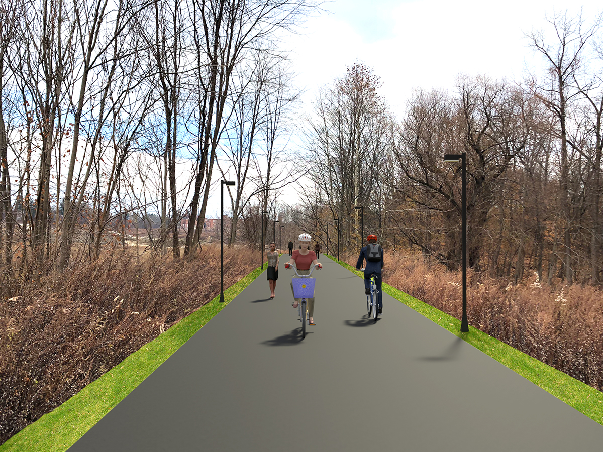
Un nuevo sendero multiuso (peatonal y ciclovía) de 1,2 millas está cambiando el aspecto de Poughkeepsie al brindar un acceso sin precedentes a vecindarios residenciales y comerciales en la ciudad y en el pueblo.
Recorriendo desde el nuevo Hudson Heritage Plaza en el pueblo hasta Parker Avenue en la ciudad, el sendero sirve de nexo clave para los vecindarios del Northside de la ciudad, donde muchos hogares enfrentan retos económicos y pueden no tener acceso a un vehículo. El sendero está iluminado y bajo monitoreo por video las 24 horas.
Al reconocer su potencial para conectar no solo distintos vecindarios sino además el Marist College con el Mid Hudson Regional Hospital, Scenic Hudson negoció y financió la adquisición del antiguo corredor ferroviario en 2019. en 2020, la legislatura del condado de Dutchess resolvió por unanimidad asumir propiedad de dicho corredor a fin de desarrollar y mantener un nuevo sendero, nombrado Marcus J. Molinaro Northside Line en 2023.
La MJM Northside Line continuará brindando acceso seguro y conveniente entre el Northside de la ciudad y los vecindarios norte del pueblo. También ofrece una manera de ir a pie o en bici, sin necesidad de vehículo, al trabajo, la escuela, tiendas, instalaciones médicas y parques públicos. La gente que vive en las áreas adyacentes del sendero se beneficiarán al máximo de esta nueva infraestructura verde. Con su potencial de llevar a nuevas personas a distintas áreas de la ciudad, la MJM Northside Line podría crear oportunidades económicas para Poughkeepsie.
El Condado Dutchess lleva la dirección general del proyecto, desde diseño preliminar y permisos hasta la construcción final. El socio de proyecto Scenic Hudson hizo posible el proyecto al adquirir las antiguas vías ferroviarias. Hudson Valley Engineering Associates (HVEA) de Beacon es ingeniero de diseño del nuevo sistema de senderos y ayuda además al condado con los permisos ambientales necesarios. Susan G. Blickstein, LLC asiste a HVEA, Inc. en extensión y participación comunitaria.
La terminal sur del sendero propuesto empieza en N. Hamilton Street en la Ciudad de Poughkeepsie y se dirige hacia el norte. Tras cruzar el Dutchess Rail Trail, cruza el Northside de la ciudad, pasando el Mid Hudson Regional Hospital. En el pueblo, el sendero pasa por Fox Run at Fulton antes de terminar en el Hudson Heritage. Otro ramal del sendero empieza en la calle Fulton, se dirige al suroeste pasando el Marist College, y termina cerca de Kittredge Place, no lejos del río Hudson.
La Northside Line conectará también más de una docena de recursos comunitarios, brindando una nueva opción de acceso y apoyando sus programas y actividades. Entre ellos se cuentan: las escuelas primarias Morse y Warring, el Family Partnership Center, la Iglesia Bautista Beulah, el Dutchess County Mental Health Campus, la Pasarela sobre el Hudson, el Arroyo Fall Kill, el lago Morgan y Quiet Cove Riverfront, Pulaski, Mansion Square, y College Hill Parks.
El primer segmento del sendero ya se encuentra abierto para uso público. El tramo de 1,2 millas con un sendero multiuso (cerrado a vehículos motorizados) para peatones y ciclistas va desde el Hudson Heritage Plaza en el Pueblo de Poughkeepsie hasta Parker Avenue (State Route 9G) en la Ciudad de Poughkeepsie. Para más novedades, visitar: https://www.dutchesscountyurbantrail.com/news-updates
La seguridad de la Northside Line es un componente clave del diseño. Habrá dos secciones: una mayor parte para uso dividido (zonas separadas para peatones y para ciclistas) y el resto para uso compartido. Donde haya limitaciones en la anchura del sendero, o donde se prevea un menor uso, se propone un enfoque de uso compartido. Se integrará alumbrado y señalización a lo largo de la red de senderos. Asimismo, se está dialogando con las unidades de primera intervención que asisten en el sendero para integrar sus aportes en la elaboración y la implementación del diseño final del proyecto.
La participación pública es de vital importancia en el diseño y los usos futuros del sendero. La fase de diseño empezó con una encuesta en línea a la comunidad y reuniones virtuales para recibir sus aportes, comentarios que desde ya están orientando los pasos a seguir. A medida que se planifican nuevas oportunidades, se están recibiendo aportes y preguntas de la comunidad en urbantrailproject@dutchessny.gov.Para más detalles, visitar https://www.dutchesscountyurbantrail.com.
El Condado Dutches reconoce el potencial de gentrificación y el riesgo relacionado de aumentos en los valores de propiedad. Aunque este no es un proyecto residencial y no tenemos control directo sobre la asequibilidad de las viviendas, el condado está colaborando de manera activa con Scenic Hudson, Hudson River Housingy el Poughkeepsie Affordable Housing Coalition a fin de implementar políticas y ofrecer recursos para combatir los aumentos drásticos en alquileres y el desplazamiento, especialmente para la población de Northside.
Se prevé que en los comercios habrá mayor tránsito de gente que usa los senderos. La Northside Line está colaborando asimismo con la Northside Junction para mejoras a las calles como nuevas aceras, jardines y medidas para reducir la velocidad del tráfico. Haremos lo posible por emplear empresas locales en la construcción del sendero.
Es posible pero muy poco probable. El terreno fue anteriormente propiedad de CSX y fue adquirido mediante el proceso federal sobre banca de vías ferroviarias, que permite a una agencia ferroviaria y una de senderos colaborar en el uso de corredores fuera de servicio hasta que se necesiten de nuevo para servicio ferroviario. De los cientos de senderos en vías ferroviarias que se han creado a nivel nacional desde el inicio del programa en 1983, muy pocos han sido reactivados para uso ferroviario.
Sí, el sendero comprende alumbrado y monitoreo por cámaras de seguridad y patrullaje policial para garantizar su uso seguro las 24 horas. También se sacará la nieve en invierno según sea necesario. Hay otros elementos como puestos seguros para bicicletas, bancos para sentarse y estaciones de reparación de bicicletas.
Novedades/Eventos/Más